Cross Charlotte Trail
- Project typeTrails & Paths
- Project budget$112.9 million for all segments

Program Overview
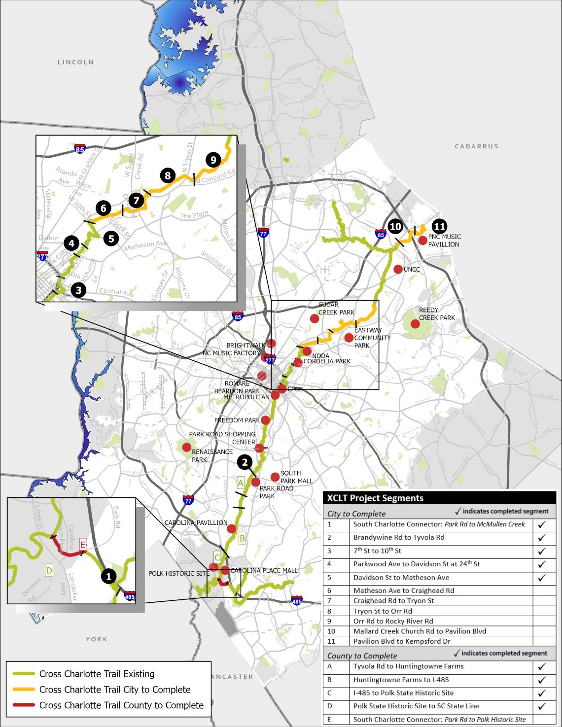
The City of Charlotte is partnering with Mecklenburg County to create a 30+-mile trail and greenway facility that will stretch from the City of Pineville through Center City and on to the UNC Charlotte campus and Cabarrus County line. Once completed, the Cross Charlotte Trail will allow residents to travel seamlessly from one end of Charlotte to the other. Approximately 140,000 residents and 130,000 jobs will be within walking distance of the proposed trail and the adjacent greenways that connect to it.
Cross Charlotte Trail Segments
There are 11 total segments of the Cross Charlotte Trail, plus a bicycle boulevard that improves connectivity to the trail in North Charlotte.
Active Segments in Progress
Segment 6: Matheson Avenue to East Craighead Road
Segment 7: East Craighead Road to North Tryon Street
Segment 9: Orr Road to Rocky River Road West
Segment 10: Mallard Creek Church Road to Pavilion Boulevard
Segment 11: Pavilion Boulevard to Kempsford Drive
Completed Segments
Bicycle Boulevard
Segment 1: South Charlotte Connector
Segment 2: Brandywine Road to Tyvola Road
Segment 3: 7th Street to 10th Street
Segment 4: Cordelia Park
Segment 5: North Davidson Street to Matheson Avenue
Segment 8: North Tryon Street to Orr Road
Program Goals
- To be nationally recognized by putting Charlotte among the top 25 cities in the country with the most multi-use trails
- To be continuous by closing the gaps between existing trails, thereby creating 26 miles of continuous trail for commuting and exploring as you travel to your desired destination
- To be connected by providing a seamless path connecting people to the larger trail network without using a car
- To be separated by creating a comfortable trail separating you from vehicle traffic for a safe and enjoyable experience
- To be convenient by offering transportation choices and convenient access to neighborhoods and businesses across Charlotte
Map of the Alignment
The map below shows the entire alignment of the trail from the South Carolina state line to Kempsford Drive near the Cabarrus County line. Click on the map to view a larger version.